The coast that made Chennai
Account subscription benefits alongside Premium Stories, Editorials, Opinions and more. Unlock these with Subscription
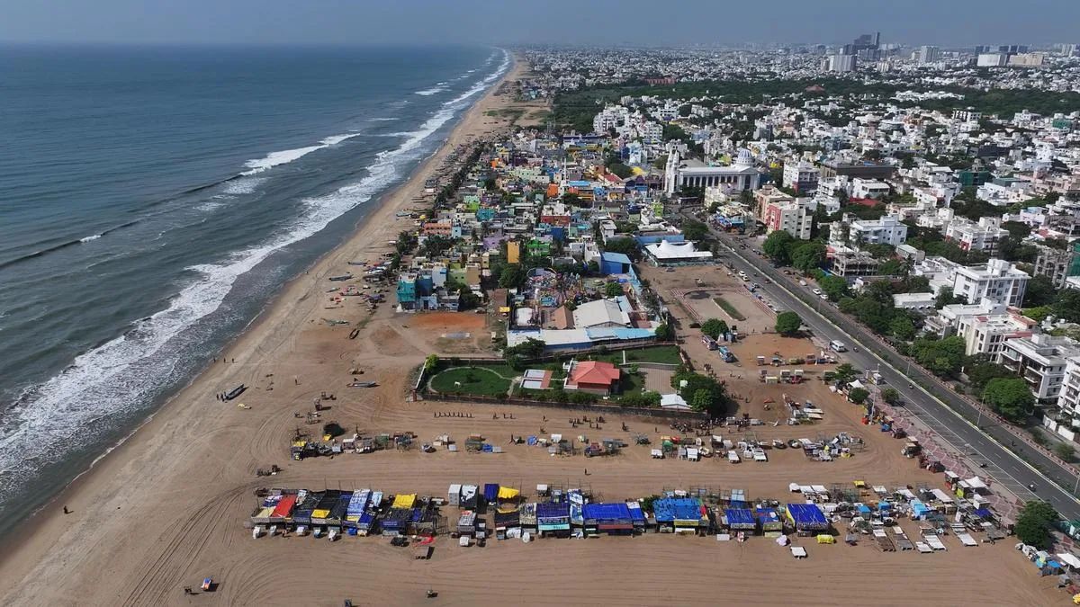
The beaches to the south, including Besant Nagar, have seen residential development and recreation. | Photo Credit: B. Jothi Ramalingam
Look out of an aircraft window as it descends into Chennai and the coastline is the first thing that catches your eye. A long blue-grey edge against the city, with the sea on one side and the sprawling city on the other. From up there, it looks permanent, almost as though the line where the land ends and the sea begins has always been exactly where it is today.
Before Madras became a colonial trading centre, the coast was home to fishing settlements, and it was in this coastal landscape — between the Cooum and the Adyar and near the older settlement of Mylapore — that the English eventually chose to establish Madraspatnam in the 17 th century, which grew around Fort St. George into the city we know today.
The coastline that greets a visitor today is very different from the one that would have greeted a sailor arriving in Madras two centuries ago. Even the Marina, one of the city’s most recognisable landmarks and among the world’s longest urban beaches, is not quite the wide stretch of sand it appears to be. Its present form is closely linked to the construction of its harbour in the late 19 th century, one of the biggest changes made by humans to Chennai’s coast.
Besides providing ships a sheltered place to anchor, the harbour also interrupted the movement of sand along the coast. The present Marina developed gradually over a century, through the trapping and deposition of sediment following the construction of the artificial harbour.
And while the beach to the south of the harbour grew, the situation to the north was very different, says Karthik Gunasekaran, co-founder of Aram Thinai, an environmental organisation. The same breakwaters that trapped sand on one side of the harbour interrupted the supply to the northern coast, contributing to erosion along stretches of North Chennai.
As Madras grew into an industrial and commercial centre, more port infrastructure came up along the coast — Kamarajar Port, formerly Ennore Port, followed by Kattupalli further north — adding more breakwaters and structures to an already altered shoreline, says Mr. Gunasekaran.
Writing in The Hindu on January 25, 1959, naturalist M. Krishnan described a Marina that was a vast, open landscape, where fishermen mended and dried their nets, young boys hunted crabs, old men angled with primitive tackle, and herdsmen brought their buffaloes to bathe in the sea. Catamarans and traditional masula boats stood on the sand, while shells, crabs, and other debris washed up along the waterline. For Krishnan, the beach was also a democratic public space, where judges, lawyers, clerks, bosses and children shared the same stretch of sand.
However, urbanisation has changed the way the shore is perceived, often alienating fishing communities from the spaces they traditionally occupied, says Mr. Gunasekaran. “Earlier, there were 10 hamlets near Marina; now there are only three.
5News aggregated this summary from the outlet’s public feed. The full article, with all the context, is on www.thehindu.com — the content belongs to The Hindu - National.